Geology-Areas of interest-Intertropical area
This area located around the Equator is sensitive to climates varying from hot and warm – propitious to the development of thick lateritic weathering profiles- to seasonally dry where mechanical erosion is active through the development of several kilometers long glacis. The Geology team is involved in several intertropical areas to study lithospheric and climatic forcing on sediment transfers.
1- West Africa
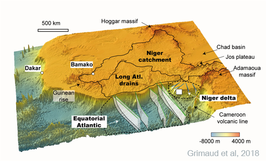
3D view of subSaharan West Africa with the main catchments and associated accumulation sedimentary basins (Grimaud et al., 2018)
|

Example of lateritic weathering profile capped by the High Glacis ferricrete, NW Burkina Faso. |
In collaboration with the GET Toulouse and Total, the surface dynamics of an area bounded by a complex passive margin to the South and a hostpot swell to the North (Hoggar massif) is studied by the team from about 45 Ma to the present, hence since the abandonment of the fundamental “African” surface that developed during the warm climates of End Cretaceous and Paleogene. River long profiles evolution, ranges of cratonic and swell denudation, and sediment budgets between the continent and the margin have thus been quantified, bringing new constraints on vertical movements in the area (Grimaud 2014, PhD). Ongoing work is focusing on offshore sedimentary architectures to quantify the associated volumes deposited during the Cenozoic, with the aim to reconstruct offshore and onshore geological evolutions.
2- Bangladesh
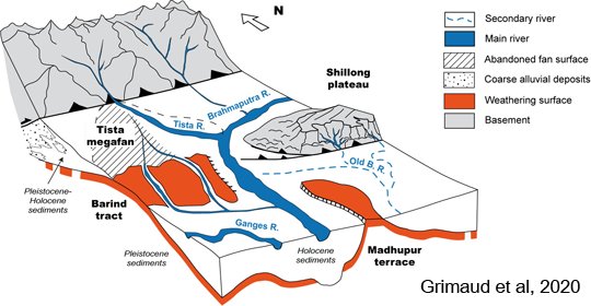
3D sketch of the subsurface Quaternary deposits in the Garo-Rajmahal Gap, NW Bangladesh (Grimaud et al.,2020) |
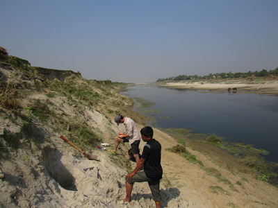
Fine sand sampling along the bank of a side Channel of the Ganges River, NW Bangladesh.
|
In collaboration with the Universities of Minnesota, Vanderbult and Lamont-Doherty, Quaternary deposits dynamics in the Himalayan foreland is being studied by focusing on forcings that impact river mobility and the associated stratigraphical architecture. By mapping the distribution of Pleistocene (paleo) soils –combined with geophysical and geochemichal data- flexural deformation pattern of the foreland, which affects sediment distribution, is suggested. In parallel, experimental simulations suggested that in the area interactions between multiple alluvial sources has an impact on the mobility of rivers such as the Brahmaputra and Teesta. Currently, ongoing work focuses on more accurate characterization and dating of the Pleistocene soils.
3- New Caledonia
In collaboration with the HR team, a project hosted by the University of Lorraine has started to characterize and restitute the geomorphic evolution and associated lateritic weathering profiles on mining sites of New-Caledonia with the aim to model Ni-Co supergene enrichment. The team is involved in the mapping and reconstruction of topographic evolution and weathering profiles development using field, core and DEM data.